


2021-10-29 Rando CVA Col de la Chaudiere vers Bourdeaux

holtzv
User GUIDE
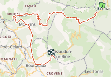

Length
23 km

Max alt
1079 m

Uphill gradient
482 m
Km-Effort
31 km

Min alt
385 m

Downhill gradient
1013 m
Boucle
No
Creation date :
2021-10-29 06:54:30.431
Updated on :
2021-11-01 07:59:58.789
5h54
Difficulty : Difficult

FREE GPS app for hiking
 SityTrail
IGN / Geographical institutes
SityTrail Plus
The world is yours!
About
Trail Horseback riding of 23 km to be discovered at Auvergne-Rhône-Alpes, Drôme, La Chaudière. This trail is proposed by holtzv.
Positioning
Country:
France
Region :
Auvergne-Rhône-Alpes
Department/Province :
Drôme
Municipality :
La Chaudière
Location:
Unknown
Start:(Dec)
Start:(UTM)
674765 ; 4944130 (31T) N.
Comments